Chapter Two

The Old Junctions at Killamarsh


As an introduction to one of the mammoth series of mosaic pieces on Flickr, the main part of the 3 showing a series of maps of the area of the Killamarsh Junctions. The maps, taken from old OS maps from 1906, 1923, 1953 and 2004 and in addition, the least contaminated (by vegetation) picture from Google Earth, in 1999; what a pity this couldn't go back to 1950, 1850.. and onwards, where's Dr. Who when you need him... see-
the maps for Killamarsh Junctions 
  • on the left, from 1906, the map shows what was in place at that time; namely- the Midland line in the centre of the 3 aligned north-south and turning off to Staveley and Barrow Hill at bottom left, 
  •  the GC 'fly-over' coming in from Sheffield in the north-erst and at bottom, heading south-east to Annesley,
  •  the Waleswood connection to the GC curving off to the north-east at centre over to Wales,
  • the goods line from the Midland over to Kiveton colliery at centre and passing under both the GC and LDECR, heading almost due east,
  •  the LDECR line commencing at Beighton junction, top centre right line and heading due south to Spinkhill and Lincoln, passing over the Waleswood curve about half down the map.
  •  the Holbrook colliery goods line, at the left of the main lines.
All 3 stations are identified on this map and are situated just south of the main east-west road; on the Midland is Killamarsh (later Killamarsh West), at centre on the MSL/GC line is Killamarsh (confusingly, so later named Killamarsh Central) and finally at right Upperthorpe and Killamarsh on the LDECR.


This is almost a piece which could be summarised by the poem, 'The Way through the Woods' by Rudyard Kipling-

They shut the road through the woods
Seventy years ago.
Weather and rain have undone it again,
And now you would never know
There was once a road through the woods
Before they planted the trees.
It is underneath the coppice and heath,
And the thin anemones.
Only the keeper sees
That, where the ring-dove broods,
And the badgers roll at ease,
There was once a road through the woods.

Yet, if you enter the woods
Of a summer evening late,
When the night-air cools on the trout-ringed pools
Where the otter whistles his mate,
(They fear not men in the woods,
Because they see so few.)
You will hear the beat of a horse's feet,
And the swish of a skirt in the dew,
Steadily cantering through
The misty solitudes,
As though they perfectly knew
The old lost road through the woods.
But there is no road through the woods...


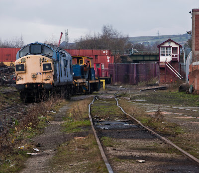
Threre is however little of the track and infra-structure remainig, _except_ of course, the huge, multi-arch LDECR bridge, the northern end of which is featured in the picture above.

The central section of this large mosaic shows a larger portion of the Killamarsh area of the 1953 OS map and now indicates where the connecting chords of the Waleswood curve and the Kiveton goods branch line ended on the GC's line out of Sheffield and over to Lincoln. Interestingly for this time, just east of Wales station was another of those 'Institutions', Wales Court, for the 'mentally defective', hell! there being another in the Grange Lane area pictures & maps (from the same time, 1953) which are available here-
Grange Lane area pictures & maps
in this instance its the Thundercliffe Grange Institution... all very non-PC I guess now. The 1953 map also shows some other interesting features, the Norwood Tunnel carrying the Chesterfield Canal to the lower right and closely following the Midland goods line over to Kiveton colliery. The Canal has been the subject of huge restoration efforts and I understand that the so-called 'last 9 miles' is to be completed and would bring the canal along this disused and overgrown section, from Kiveton, into the Country Park and then on down the side of the GC to Staveley Basin; a great deal of work to be done. The area of the map around the Beighton junctions has been drastically changed as the A57 now marches straight across the triangle of lines in the top left-hand corner and has resulted in the cutting off the B6053 Beighton road before it crossed the Midland line on this map. What is also seen is that there was yet another curve over to the Brookhouse Colliery from the Midland line below the B6053 and connecting to the GC Lincoln line at the colliery, itself having a large array of sidings in the corner where the Midland and GC lines cross; Pigeon Bridge Brook was the southerly boundary of the colliery and this is still present, though in the tangle of excavated land above the country park, hard to see. Also marching through the right section of this map, from north to south and crossing both the disused canal bed and the Kiveton goods track-bed, is the M1 motorway and crosses them just about where the word 'Tunnel' appears alongside the Kiveton branch line. Much else has gone of course, Waleswood Hall, Brook House, The Old Quarry, Pit Houses and Kesteven Bridge; Bedgreave Mill (now the Rother Valley Country Park visitor centre) and 'The Green' remain. The only main line railway left is 'The Old Road', the North Midland line from Chesterfield, Barrow Hill and on through Masbrough, joining what is now 'The Midland Main Line' from Sheffield at Masbrough north junction; all other lines in the Killamarsh area have been removed and the track-beds are at best hard to follow or at worse, under the waters of the country park.
What a grand place this would have been in the 1st part of the last century, with 3 main lines, junctions, collieries, mills, sidings and all the rail paraphernalia associated with all this. Its difficult to imagine now and sadly, this is one of the places I never managed to get to in the late 50's and 60s when rail, as well as coal, was still, just about, king...


Originally, the images were ordered numerically from upper left, not in chronological order and anti-clockwise, the numbers here refer to the original mosaic piece on Flickr, see-
Killamarsh Junctions Flickr Mosaic 
Here thepictures are in appropriate order for the discussion in the blog-

1.
A Freightliner class 66, 66955, on the lunchtime, 4O55, Leeds FLT to Southampton MCT working, it is heading down the Midland line having just come under the huge lattice bridge which carried the GC line from Sheffield Victoria down through Annesley and on to London Marylebone. The line the Freightliner is on passes through Killamarsh on down to Barrow Hill & Chesterfield and southwards to Southampton. 

2.
 In similar fashion, but about an hour and a half earlier, an EWS class 66, 66164 this time the 6X01 rails on the Scunthorpe Trent TC to Bescot up engineers sidings and in this instance during the period the sun was out. 

3.
The Network Rail Test Train, here hauled by 31233 with 37682 at the rear and is on the 1Q13 on the 14th November and just about visited the whole of the local network around here, even travelling up towards Stocksbridge Works just prior to appearing here at Beighton junction on the GC line.

4.
 From a negative scanned by Adrian Wynn and with permission to reproduce here, this is 45221? (not sure about the 1st digit, but I guess some will be) and the train is here seen heading north at Killamarsh West, the Midland station on the line where the Freightliner and EWS are passing along and heading south, separated in time by about 50 years though! The Midland goods line to Kiveton colliery can be seen in the background on the left and has some wagons in one of the sidings. Inspection of the map will reveal this line veered off almost exactly due east to pass under both the GC and LDECR lines and so on to Kiveton. Also in the top left corner, at the end of Glovers sidings, which came off the LDECR, is the Victoria flour mill which was situated just to the north of the Killamarsh Central station.

5.
On the same section of line, 50 or so years later, GWR Castle Earl of Mount Edgcumbe, 5043 rounds the bend close to the Midland junction track-bed over to Kiveton colliery, this time on the 1Z43, Tyseley Steam Trust to York tour and in damp air a grand plume of steam. Pylons have been erected in the intervening years between the passage of 5043 and 45221...

6.
Coming under the bridge from which the picture of 45221 was taken, GWR Castle Earl of Mount Edgcumbe, 5043 makes a fine show in this image where much 'twig' vegetation was cloned out of the picture on the right, which if left would have spoilt the whole right side of the loco.

7.
Beyond the rear of the loco, around the bend and under the Killamarsh to Beighton road was the Midland's station, Killamarsh West. In the lower part of the 'Then & Now' picture, Stanier class 8F. 2-8-0 48439 passes through the station site heading north and again, 50 years or so later, 47843 Vulcan, is heading in the same direction on the 0Z70, Washwood Heath to Doncaster Wabtec, working in early November last year.

8.
From a negative scanned by Adrian Wynn and with permission to reproduce here, this is Killamarsh Central from the south looking towards the GC station after closure and the weeds had taken over. The station building is now fenced off and the tracks look as if they haven't been used for a while, which is exactly the case; the station closed to passengers in March 1963 and closed completely in June 1965; the tracks remained in use until 1981 serving the Arkwright Colliery at Staveley and were finally lifted in February 1983. The station building was bought by Havenplan in 1965 as an 'Antiques Emporium' and this usage lasted into the 21st century after which the building went through various phases of an attempt at being preserved, it being 1 of only 2 timber buildings on the line. These all failed and the building has been dismantled, leaving only the iron pillars visible on a site which ... looks a complete mess!

9.
The next 3 images are from the book by Chris Booth on the LDECR and published by Blurb publications, and with permission to reproduce here, this is the remains of Upperthorpe & Killamarsh Station on the LDECR looking over the (derelict) Chesterfield canal, southwards through the station site; one set of tracks having been removed from the canal bridge. On the right, the home to the short-lived Rother Valley Railway which was to run a heritage railway between here and the site of Westhorpe colliery just this side of Spinkhill tunnel.

10.
Again from the LDECR book by Chris Booth, with permission, the remains of Upperthorpe & Killamarsh Station on the LDECR sees 63703, 04/8 2-8-0 pass on an up empties to Westhorpe Colliery in June 1960; the remains of 1 platform is on the left and the canal bridge is beneath wagons 4 & 5 and the picture looks north towards Beighton junction.

11.
Last of the 3 pictures from Chris's book, with permission, now early on in the last century as the station is Killamarsh on the LDECR which subsequently became Upperthorpe & Killamarsh in 1907 when the GC station materialised, it being Killamarsh Central; this picture once again is looking south towards Westhorpe and Spinkhill.

12.
A contemporary picture to that shown in #9, this is also looking south across the (derelict) Chesterfield canal over-bridge and now there is little to recognise as a once great railway.. well 'the Clog & Knocker' as it was affectionately called or, better, 'The Dukeries Route'. Continuation from here is difficult without resorting to an excursion down onto the bed of the canal and back up again and more profuse vegetation... but it will be done!

13.
As well as the 3 main line bridges (Midland, GC and LDECR) over the River Rother, between the GC and LDECR was yet another, at ground level, carrying Glover's Siding, to the Victoria Flour Mill, seen in picture 4. This bridge has long since been removed but in this picture, the cutting walls festooned with graffiti and amidst abundant vegetation is the deep cutting taking the track-bed up to the LDECR and forming as junction with it just north of the south connection between the LDECR and GC line, barely discernable on the map.

14.
This is the point on the LDECR where a connection went off to join the GCR, seen at far upper left in the photograph, making a junction with the GC at Killamarsh Junction where there a signal box was situated also controlling the line to over to Waleswood. Here we see what is left of Killamarsh south junction, on the other side of the railings, commencing on the bridge carrying the LDECR track-bed. It is at this point where the line diverged on the section of track-bed to the right of the photograph, the bridge having been reduced in width from the original layout. Below is the 3rd of the paths mentioned earlier which crossed the Midland, GC and LDECR lines; in this case it went under the GC, Glover's Siding and LDECR lines.

15.
The Midland had a line from a junction (see pictures of 45221, #4 and the Earl, #5) on the Old Road just north of Killamarsh West station and over to Kiveton Colliery, this is the LDECR bridge over what now remains; only the track bed, a quiet spot, so well graffiti'd. This picture is looking south down the LDECR line to what was once Upperthorpe & Killamarsh Station and is north of the last picture at Killamarsh south junction. Another relatively substantial structure for a goods line over to the colliery but when 'coal was king', I guess the financial outlay on building, not only this 'branch', but also the Waleswood curve and the Brookhouse line were all worth the time and money.  
 
16.
From yet another negative scanned by Adrian Wynn and with permission to reproduce here, this is 63841 heading towards Wales station on the Waleswood Curve, leaving the MSL/GC line here at Killamarsh north junction and heading north-east to pass under the LDECR line, whose signals can be seen in the photograph, a short way off on the left. The photograph is taken from the 'V' in the junction at the Killamarsh junction signal box, of which there are still brickwork remnants to be seen, see picture 21. The Victoria flour mill is visible again in the distance just north of Killamarsh Central station through which the train will have just passed. The telegraph post just to the left of the loco, I think is part of the signal box remains which can be seen in picture 21 below, which has an inset showing the pile of bricks and the post. What look like wisps of steam can be seen on both the Midland line to the right of the flour mill and, in the distance, centre right another which, from the elevation looks to be on the LDECR... 

17.
The large, 7-arch LDECR bridge which carried the line across a small valley is now hidden in the trees and east of this large structure is now the Rother Valley Country Park. The ends of the bridge have been blocked off with metal panels, for safety reasons I guess, and so the panels provide an ideal opportunity for some lively graffiti in this very glum setting; this is one of the panels and have to admit - I quite like it.

18.
The last of Adrian Wynn's scanned negatives and with permission to reproduce here, this is an EE type 3 diesel heading towards Retford from Sheffield Victoria. It is just about to pass through Wales station at this end of which can be seen the Wales station signal box. The main road from Rotherham to Killamarsh passes underneath in the right foreground and the Waleswood curve from Killamarsh north junction trails in at lower left and the Waleswood colliery was on the right, opposite the signal box.

19.
And here it is, the large, 7-arch and one lattice metal span LDECR bridge at Killamarsh carrying the high-level LDECR line over a small valley on the west side of what is now the Rother Valley Country Park. This view looks south towards the site of Upperthorpe and Killamarsh station and the Killamarsh junctions and although the site is well over-grown, the bridge structure has protected the underneath and so this is relatively clear of vegetation; parts of it having clearly been sawn off! Along with the line itself this was a huge expense for the builders of the LDECR which ultimately came under control of the GCR but which never realised the ambitions of its name; i.e. a line running between the ports on the east & west coast of the UK; the line only ever managing to operate from Lincoln to just north of here at Beighton junction; though with running powers over the Midland at Beighton to Treeton and then via SDR (Sheffield District Railway) through to its goods terminus at Attercliffe...

20.
Looking north now towards Beighton junction and we see the part of the bridge under which ran the Waleswood Curve over to the junction at Wales station seen in the earlier photographs. The space under the large lattice iron bridge is angled north east to carry the line across what is now the Country Park lake. There is now a relatively clear space underneath the bridge, but the track-bed abruptly ends just a few 10s of metres to the right on the shore of the lake at Rother Valley Country Park; the whole line having been dismantled; the remains now lie under the water... but in fact, close inspection of the GE picture in part 2 of this photo-essay, will reveal what looks like a sandy plume extending into the lake in the direction of the Waleswood curve track-bed, maybe dry conditions will reveal all. More graffiti work on the blue-brick walls, hanging plants, quiet, cool air all lend a silvan air to the place ...

21.
 And, finally, A panorama of the scene as the MSL/GC line, now a track bed, comes over the North Midland on the large lattice bridge on the left, seen in photographs 1 & 2, and joins what is now a walking path from straight ahead and proceeds on south to Annesley and Marylebone, the line and all else now all long gone. This path has been constructed between the defunct line on the right, the LDECR and the 2 lines on the left, Midland (still in operation) and the GC (closed in 1966). This picture was taken here as this spot also marks the position of the Killamarsh signal box at the north junction where the line went off to the right from the GC, over towards, and under, the LDECR bridge, to Wales; the Waleswood Curve. Close inspection of the photograph on the right will reveal a tumble of brick-work lying in a clearing which is all that now remains of the signal box. There is also, propped up just beyond the bricks, the telegraph pole which can be seen in front of 63841 in Adrian Wynn's picture, No.16 and which is also shown in more detail in the inset picture, just added at the last moment... 

page visitor counter
who is online counter blog counter

Comments

Popular posts from this blog

Chapter One